A 5-Day Seattle to Oregon Road Trip: Painted Hills, Blue Basin, Tamolitch Blue Pool, Silver Falls & Ape Cave
- 3 days ago
- 22 min read

I love a road trip that makes absolutely no sense on paper until you are halfway through it and suddenly realize you have somehow gone from dry desert badlands, to neon-blue water, to moss-covered waterfalls, to a pitch-black lava tube under Mount St. Helens.
That was this trip.
This Seattle to Oregon road trip started as a long-weekend mission to see the Painted Hills and the Trail of Ten Falls. It turned into one of the most varied Pacific Northwest road trips we have ever done, with a little bit of everything: Columbia River Gorge views, the fossil beds of Eastern Oregon, the McKenzie River corridor, Silver Falls State Park, Portland food, and Ape Cave on the way home.
It is a lot of driving. It is not the most relaxing itinerary in the world. But if you want a Memorial Day or Labor Day weekend road trip from Seattle that feels huge without needing flights, this route absolutely delivers.
Table of Contents
Adventure Stats
Trip length: 5 days / 4 nights
Best for: Memorial Day weekend, Labor Day weekend, or a flexible 5-day spring/fall road trip
Starting point: Seattle, Washington
Route: Seattle → Maryhill Stonehenge → John Day Fossil Beds → Painted Hills → McKenzie River → Silver Falls → Portland → Ape Cave → Seattle
Driving distance: About 1,000+ miles total, depending on campsites and detours
Hiking distance: About 24–26 miles total, depending on how much of Ape Cave you do
Difficulty: Moderate, mostly because of the amount of driving and the long hiking days
Favorite surprise: Ape Cave
Biggest crowd warning: Silver Falls on a holiday weekend
Most important planning tip: Download offline maps for the driving route, trail maps, and your itinerary before you go.
Quick 5-Day Itinerary
Da5y | Route | Main Stops | Overnight / Campground | Approx Driving | Approx Hiking |
Day 1 | Seattle → Columbia River Gorge / Maryhill area | Evening drive from Seattle, Columbia River Gorge views if arriving before dark | 220-235 miles | Minimal | |
Day 2 | Maryhill → John Day Fossil Beds → Painted Hills | Maryhill Stonehenge, Clarno Unit, Sheep Rock Unit, Blue Basin / Island in Time Trail, Painted Hills at golden hour | 225-250 miles | 3-4 miles | |
Day 3 | Painted Hills area → McKenzie River corridor | Sahalie Falls, Koosah Falls, Tamolitch Blue Pool via the McKenzie River Trail | 190-220 miles | 10 miles | |
Day 4 | McKenzie / Santiam Pass area → Silver Falls → Portland → Southwest Washington | Trail of Ten Falls at Silver Falls State Park, post-hike food stop at Javelina in Portland | 170-190 miles | 7 miles | |
Day 5 | Paradise Point → Ape Cave → Seattle | Ape Cave near Mount St. Helens, then drive home to Seattle | Home | 220-245 miles | 4-4.5 miles |
Day 1 is really more of a "Day 0" to get a head start on this road trip after work if you're trying to squeeze it in as part of a long holiday weekend, but you can also spread this itinerary out over the course of a week for a more relaxed, leisurely pace.
Before You Go: Important Planning Notes
Download offline maps for everything
This is not optional. Several parts of this route have spotty or nonexistent service, especially around John Day Fossil Beds and sections of the forest roads near the McKenzie River and Mount St. Helens.
Before leaving Seattle, download:
Your full Google Maps driving route
You can use my Google Maps route as a starting point.
Offline trail maps for Blue Basin / Island in Time, Tamolitch Blue Pool, Trail of Ten Falls, and Ape Cave
A saved copy of your itinerary
Campground or lodging confirmations
Any timed-entry tickets or passes
The National Park Service notes that John Day Fossil Beds is rural and has limited to no cell service in much of the monument, with only limited public Wi-Fi in a couple of locations. Official info: John Day Fossil Beds Basic Information
Check current closures before committing to the route
When we visited, the Blue Basin Overlook Trail was closed, so we hiked Island in Time instead. That ended up being a great backup, but it changed the plan.
Check these official pages before you go:
Do not underestimate holiday weekend crowds
The first few waterfalls on the South Falls / Maple Ridge side of Silver Falls were wildly crowded on Memorial Day weekend. The sections behind South Falls and Lower South Falls felt less like a peaceful waterfall hike and more like standing in a Disneyland line, slowly shuffling behind the waterfall because there were so many people trying to pass through the same narrow area.
The good news is that the crowds thin out once you continue deeper into the full Trail of Ten Falls. The bad news is that if you only do the short loop near South Falls on a holiday weekend, you may mostly experience the bottleneck.
Where to Be Extra Careful About Gas
The biggest thing I would flag for this road trip is that not every section has reliable late-night fuel. This is especially true in rural Eastern Oregon.
1. John Day Fossil Beds and Painted Hills
The John Day Fossil Beds area is rural, spread out, and not a place where I would let the tank get low. The park units are separated by long drives, cell service is limited or nonexistent inside much of the monument, and small-town gas stations may close early.
For this part of the trip, I would treat gas like water: top off before you need it.
Good practical rule: fill up before leaving the larger highway towns and again whenever you see an open station near the monument, even if you are not close to empty.
2. Painted Hills to Priest Hole Recreation Site
Priest Hole was one of the coolest camping spots of the trip, but it is primitive. There is no potable water, no trash service, and no cell connectivity. Do not drive out there assuming you can solve problems once you arrive.
Before heading to Priest Hole, make sure you have:
A healthy amount of gas
Drinking water for the night and next morning
Offline maps
Food for dinner and breakfast
A plan to pack out all trash
This is also a place where arriving in daylight makes everything easier.
3. Central Oregon to the McKenzie River Corridor
The drive from the Painted Hills / Priest Hole area toward the McKenzie River corridor is long and transitions from dry Eastern Oregon into the Cascades. This section is not as isolated as Priest Hole, but services can still be spread out depending on the exact route you take.
I would fill up before heading west into the mountains, especially if you are planning to hike Sahalie Falls, Koosah Falls, and Tamolitch Blue Pool before continuing to camp.
4. Ape Cave and Mount St. Helens
Ape Cave is not a roadside attraction with lots of services right next to it. Fill up before heading toward the cave, and make sure you have snacks, water, layers, and lights ready before leaving the main highway corridor.
Day 1: Seattle to the Columbia River Gorge

The first day of this trip is mostly about getting distance out of the way. We left Seattle after work and headed south toward the Columbia River Gorge, aiming to put ourselves near Maryhill / Goldendale for the next morning.
If you have time, this area is worth more than just a sleeping stop. The Columbia River Gorge is dramatic, dry, and open in a way that feels immediately different from Western Washington. It is a perfect transition into the high desert feel of the next day.
Day 2: Maryhill Stonehenge, John Day Fossil Beds & Painted Hills
This was the most “desert road trip” day of the itinerary, and it ended up being one of my favorites.
The route links together Maryhill Stonehenge, the Clarno Unit of John Day Fossil Beds, the Sheep Rock Unit, Blue Basin, and the Painted Hills. These places are spread out, so this is a full day even though many of the individual hikes are short.
Stop 1: Maryhill Stonehenge
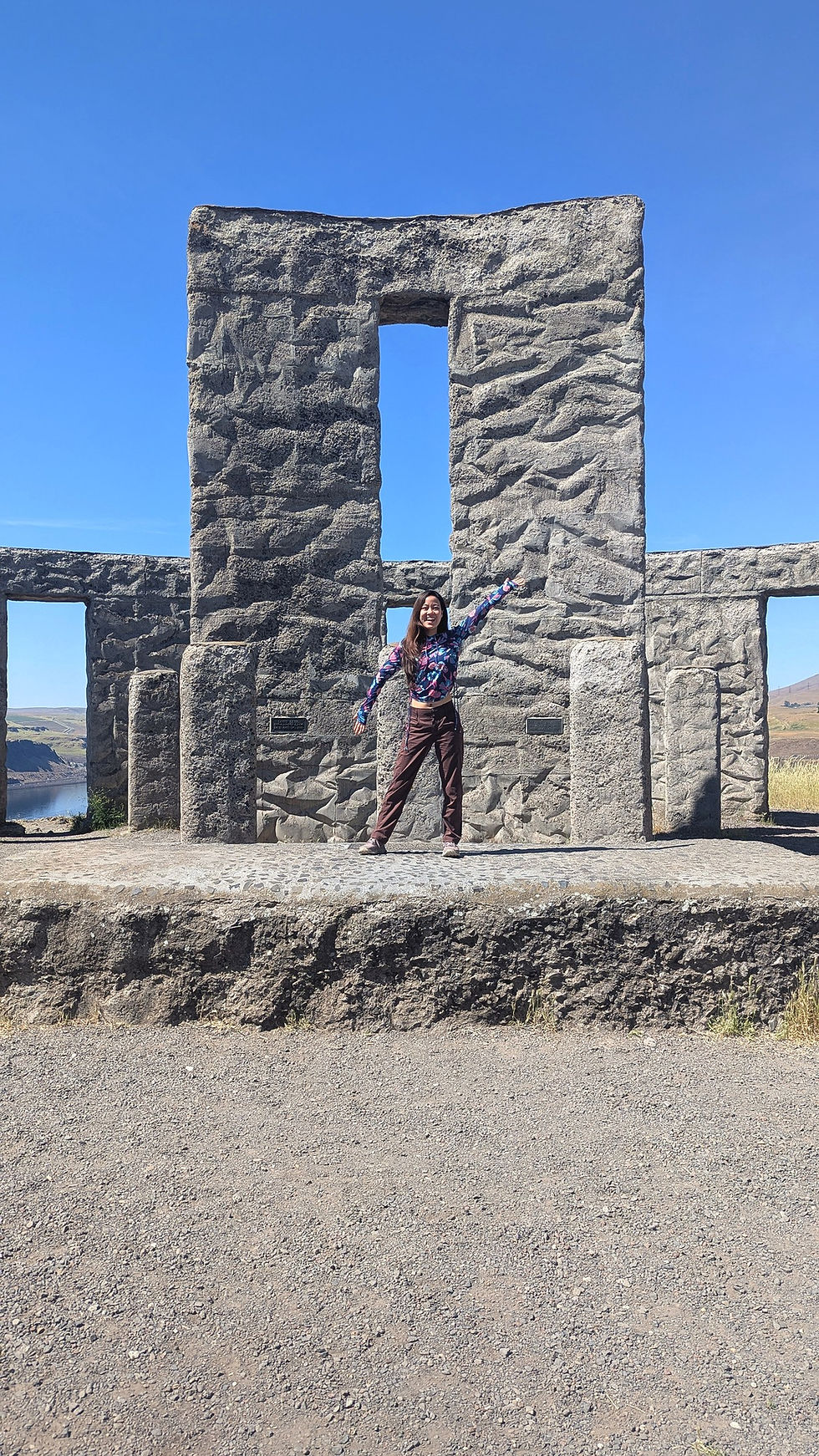
Maryhill Stonehenge is exactly the kind of strange roadside stop that makes a road trip more memorable. It is a full-scale Stonehenge replica overlooking the Columbia River, built as a World War I memorial.
It does not take long to visit, but it is absolutely worth the detour if you are already passing through the area.
Official info: Maryhill Stonehenge Memorial
Stop 2: Clarno Unit, John Day Fossil Beds

From Maryhill, continue south into Oregon toward the Clarno Unit of John Day Fossil Beds National Monument.
Clarno is the smallest-feeling of the three John Day units we visited, but it is a great first stop. The cliffs are dramatic, the trails are short, and it gives you an immediate sense that you have entered a very different landscape from the lush west side of the Cascades.
The main short trails here include:
Trail of Fossils
Clarno Arch Trail
Geologic Time Trail
Official info: Clarno Unit Trails
Stop 3: Sheep Rock Unit & Blue Basin

If you only have time for one “hike” in John Day Fossil Beds, make it Blue Basin.
The Painted Hills are more famous, but Blue Basin was the place that made me stop and say, “This feels like Death Valley.” The colors are cooler and more muted than the Painted Hills — blue-green, tan, gray, and cream — but the eroded badlands are so strange and sculptural that the whole place feels otherworldly.
There are normally two main options here:
Island in Time Trail: 1.3 miles, easier, through the canyon floor
Blue Basin Overlook Trail: 3.25-mile loop, more climbing and bigger views
When we visited, the Blue Basin Overlook Trail was closed due to hazardous conditions, so we did Island in Time instead. It was still extremely worthwhile and honestly made a better stop for an already packed road trip day.
Official info:
Stop 4: Painted Hills Unit
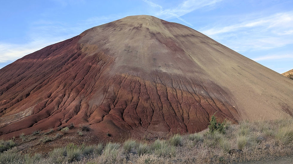
The Painted Hills are the classic postcard stop of this route, and they are absolutely beautiful — especially near golden hour. We even saw a couple people setting up for astro-photography.
This is where the hills ripple in bands of red, gold, tan, and black. The colors change with the light, so if you can time your visit for late afternoon or evening, do it.
The Painted Hills Unit has several short trails and viewpoints, so you can customize the visit depending on how much time you have. We treated it more like a scenic wandering stop than a big hike.
Official info: Painted Hills Unit
Important John Day Fossil Beds tips
John Day Fossil Beds is free to visit, but there are a few things to know:
There is no entrance fee.
Cell service is very limited.
Camping is not allowed inside the monument.
Gas and food are limited, so plan ahead.
Stay on trails. The soils and fossil-bearing areas are fragile.
Do not collect fossils, rocks, plants, or other natural items.
Official info:
Day 3: Painted Hills to the McKenzie River Corridor
After the dry, open landscapes of John Day Fossil Beds, the McKenzie River corridor feels like entering a completely different state. Suddenly you are back in deep green forest, lava rock, waterfalls, and shockingly blue water.
Sahalie Falls & Koosah Falls

Sahalie and Koosah Falls are two major waterfalls along the McKenzie River. You can visit the viewpoints quickly, hike the shorter waterfall loop, or use this area as part of a longer McKenzie River Trail day.
Official info: Sahalie and Koosah Falls
Tamolitch Blue Pool

Tamolitch Blue Pool is one of those places that looks fake in photos and then somehow still looks fake in person.
The water is unbelievably blue, and the hike to get there is a beautiful mix of forest, river, and lava rock. This area gets heavy use, especially in spring and summer, so do not expect solitude. The official Forest Service page specifically notes that the Tamolitch Blue Pool trailhead sees heavy use and recommends arriving early or late in the day when there is less traffic.
Official info:
Our route: Sahalie, Koosah & Tamolitch as a longer day hike
We did this as a longer out-and-back hike connecting Sahalie Falls, Koosah Falls, and Tamolitch Blue Pool via the McKenzie River Trail. Our version was about 10 miles total.
This was a great choice if you want the day to feel like a real hike instead of a sequence of roadside viewpoints. The downside is that you need to be ready for a bigger day, and you should pay close attention to parking, trailhead logistics, and your turnaround time.
If you want an easier version, split it into:
Sahalie and Koosah Falls as a short waterfall stop
Tamolitch Blue Pool as a separate out-and-back hike
Official info:
Day 4: Trail of Ten Falls at Silver Falls State Park

Silver Falls State Park is one of Oregon’s most famous waterfall destinations, and the Trail of Ten Falls is the reason to go.
The full Trail of Ten Falls combines the Canyon Trail and Rim Trail into a loop of about 7.2 miles. The park lists it as a moderate hike with about 800 feet of elevation variation. The route passes ten waterfalls, and several have trails that go behind the falls.
Official info:
AllTrails: Trail of Ten Falls
What the hike is actually like

The scenery is gorgeous. The canyon is lush and green, the waterfalls are frequent, and the behind-the-falls sections are genuinely cool.
But this is not a hidden gem.
On a holiday weekend, the South Falls and Lower South Falls area can be extremely crowded. The first behind-the-waterfall sections were so backed up that it felt like waiting in a theme park line. People were moving slowly, stopping for photos, trying to pass in narrow areas, and generally creating a bottleneck.
The good news: once you commit to the longer loop and get farther from the easiest-access waterfalls, the experience improves a lot. The full hike gives you more breathing room and a much better sense of the park.
Silver Falls tips
Start early or later in the day if visiting on a holiday weekend.
Expect South Falls and North Falls to be the busiest area.
Wear shoes with good traction; the trail can be slick near waterfalls.
Bring a rain jacket or shell even on sunny days because waterfall spray is real.
Pets are not allowed on the Canyon Trail or several canyon access trails, including Maple Ridge, Winter, and Twin Falls trails.
Park at South Falls as parking is limited near North Falls
Download the map ahead of time.
Official map: Trail of Ten Falls and South Falls Day-Use Map
Portland Food Stop: Javelina
After a big waterfall hike, we stopped in Portland for food at Javelina, an Indigenous dining restaurant.
This ended up being a great post-hike choice because it felt distinctly Portland without being fancy in a fussy way. The menu has options like blue corn bread, fry bread, salads, brunch dishes, and other dishes drawing from Indigenous ingredients and traditions. They also have an extensive indigenous tea menu featuring traditional roots and herbs used for healing various maladies.
Official links:
This is a good place to build into the route if you want something more memorable than a random highway meal before heading north.
Day 5: Ape Cave at Mount St. Helens

Ape Cave was the final big stop of the trip, and it is very different from the rest of the itinerary.
This is not a normal hike. Ape Cave is a lava tube near Mount St. Helens, and once you are inside, it is dark, cold, rocky, and completely unlike hiking above ground.
Official info:
Lower Cave vs. Upper Cave
There are two main directions from the cave entrance:
Lower Cave

The Lower Cave is the easier route. It is still dark, uneven, and cold, but it is more approachable and family-friendly than the Upper Cave.
Upper Cave

The Upper Cave is the adventurous route. It includes scrambling over rock piles, rougher footing, and more physical effort. If you want the full Ape Cave experience, this is the route that feels more like an underground adventure.
The moss-covered skylights are only accessible from the Upper Cave. If those are a priority, do not only do the Lower Cave.
Ape Cave tips
Reserve timed entry in advance through Recreation.gov. Only one is needed per vehicle - we accidentally purchased two time slots!
Bring at least two light sources per person. Headlamps are recommended if you're doing the upper route so that you can leave your hands free for scrambling. Extra batteries or an extra headlamp are a good idea in case your head lamp runs out of battery. There is a gift shop near the entrance that provides lantern rentals.
Wear warm layers; caves are cold even when it is warm outside.
Wear sturdy shoes with grip.
Do not rely only on a phone flashlight.
Bring gloves if doing the Upper Cave, since you may use your hands on rough and/or slimy lava rock.
Expect the Upper Cave to take more time than the mileage suggests.
Where We Camped on This Road Trip

One thing that made this Seattle to Oregon road trip work was breaking up the driving with practical campgrounds along the route. This was not a stay-in-one-place kind of trip. We camped somewhere different each night, slowly looping from Seattle through the Columbia River Gorge, Eastern Oregon, the McKenzie River corridor, Silver Falls, and back toward Washington.
Here is where we stayed:
Night | Campground | Best For |
Night 1 | Maryhill State Park | Breaking up the drive from Seattle and starting near Maryhill Stonehenge |
Night 2 | Priest Hole Recreation Site | Primitive camping near the Painted Hills |
Night 3 | Big Meadows Horse Camp | Positioning near the McKenzie River / Santiam Pass area |
Night 4 | Paradise Point State Park | A convenient final night near I-5 before Ape Cave and the drive home |
Night 1: Maryhill State Park
Our first night was at Maryhill State Park, right along the Columbia River near Goldendale, Washington. This was mostly a strategic first-night stop: it let us leave Seattle after work, get a few hours of driving done, and wake up already close to Maryhill Stonehenge.
Maryhill State Park is convenient, reservable, and developed, with restrooms, water, picnic tables, and fire rings. It is not a secluded wilderness campground, but it is exactly the kind of place that makes sense when you are trying to turn a long drive into a workable road trip.
A few notes from our stay:
We arrived after dark, which made it harder to understand the campsite layout.
There were signs about staying off certain lawn/tent-pad areas that we missed in the dark.
Sprinklers came on and hit our tent for about an hour.
The campground is close to trains, so light sleepers may want earplugs.
It is still a very useful first-night stop if you are driving from Seattle toward John Day Fossil Beds.
Would I stay here again for this route? Yes — but I would try to arrive before dark and pay closer attention to the tent pad/lawn setup.
Night 2: Priest Hole Recreation Site
The second night was at Priest Hole Recreation Site, a primitive BLM camping area near the Painted Hills.
This was the most scenic and “road trip adventure” campsite of the route. We stayed in the dispersed camping area and had Painted Hills-style desert views, which made it feel much more special than a standard campground. It was also a great location for ending the John Day Fossil Beds day, since we had visited Clarno, Blue Basin, and the Painted Hills before camping nearby.
That said, Priest Hole is not a campground where you should arrive unprepared. There is no potable water, no trash service, and no cell service. The roads in can be rough, especially after wet weather, and this is not a place I would casually tow a large trailer into.
Important tips for Priest Hole:
Bring all the water you need. You can get potable water at the near-by Painted Hills picnic area.
Pack out all trash.
Download maps before arriving.
Do not expect cell service.
Be prepared for primitive toilets only.
Watch for rattlesnakes.
Check road and fire conditions before committing to the drive in.
This was probably the most memorable campsite of the trip, but it is also the one that requires the most self-sufficiency.
Night 3: Big Meadows Horse Camp
If you can get a site, Cold Water Cove Campground is a great base for this area. It sits near Clear Lake, which is also worth visiting if you have extra time. We unfortunately were unable to snag advanced reservations at Cold Water Cove or any of the campgrounds immediately near the Sahalie Falls, Koosah Falls McKenzie Lake corridor.
Our third night was at Big Meadows Horse Camp, in the Willamette National Forest near the Santiam Pass / McKenzie River side of the route.
Despite the name, we did not have horses. We used it because it worked well geographically after our McKenzie River day and positioned us for the next part of the route. It is an equestrian-oriented campground, so the sites and amenities are built around horse camping, but it can still be a practical overnight stop if you find availability and are comfortable with a more basic forest campground.
This campground has picnic tables, vault toilets, and hand-pump drinking water. It is more developed than Priest Hole but still feels much more remote than a state park campground.
A few things to know:
Some sites are reservable, and some may be first-come, first-served.
Download the Recreation.gov app and campground details before arriving, since service can be limited.
The campground is seasonal and access can depend on road and snow conditions.
It is a horse camp, so expect equestrian infrastructure like corrals, hitching areas, and stock amenities.
Would I describe this as a destination campground? Not really. But for this specific itinerary, it was a useful overnight stop between the McKenzie River corridor and Silver Falls.
Night 4: Paradise Point State Park
The final night was at Paradise Point State Park, near Ridgefield, Washington. This was the least glamorous campsite of the trip, but it served an important purpose: it put us close to I-5 and made the next morning’s Ape Cave stop much easier.
After several nights of more rugged or spread-out camping, Paradise Point felt convenient because it had developed campground amenities, including restrooms and showers. It is near the freeway, so I would not go here expecting a peaceful backcountry feel. But as a final-night logistics stop, it worked well.
This is a good campground to consider if you want:
Showers after several days of camping and hiking
An easy I-5 location
A practical stop before Ape Cave or the drive back to Seattle
A lower-effort final night after a packed road trip
For this itinerary, Paradise Point was less about being a scenic destination and more about making the last day easier.
Overall Camping Thoughts
This camping sequence worked well because each campground solved a different problem.
Maryhill State Park made the first night manageable after leaving Seattle. Priest Hole gave us the best scenery and the most memorable camping experience. Big Meadows Horse Camp placed us near the McKenzie River / Santiam Pass area after a long hiking day. Paradise Point gave us showers, restrooms, and easy I-5 access before Ape Cave and the drive home.
If I repeated this road trip, I would keep the same general structure but make two changes: I would arrive at Maryhill before dark, and I would build in more time around the McKenzie River corridor. That area deserved more than just one hiking day.
Hour-by-Hour Itinerary
This is a realistic version of the itinerary, based on how the trip actually went. We naturally woke up closer to 8–9 a.m. most mornings, packed sandwich/snack lunches, and arrived at camp late. The one exception was the first night, when we left Seattle after work and arrived at camp in the dark. For the rest of the trip, this schedule felt ambitious but realistic.
Day 1: Seattle to Maryhill State Park
Time | Plan |
5:00 p.m. | Leave Seattle after work. |
6:30 p.m. | Quick dinner / gas / grocery stop along the way. |
7:00 p.m. | Continue driving toward the Columbia River Gorge. |
10:00 p.m. | Arrive at Maryhill State Park and set up camp. |
10:30 p.m. | Sleep. |
Day 2: Maryhill Stonehenge, John Day Fossil Beds & Painted Hills
Time | Plan |
8:30 a.m. | Wake up at Maryhill State Park. |
9:00 a.m. | Breakfast, pack up camp, refill water. |
9:45 a.m. | Leave Maryhill State Park. |
10:00 a.m. | Visit Maryhill Stonehenge. |
10:30 a.m. | Start driving toward Oregon and John Day Fossil Beds. |
11:45 p.m. | Quick food / snack / supply stop in Wasco or another small town along the route. Do not count on a huge grocery selection. |
1:00 p.m. | Arrive at the Clarno Unit of John Day Fossil Beds. Hike the short trails and look for leaf fossil impressions. |
2:15 p.m. | Drive toward the Sheep Rock Unit. |
3:45 p.m. | Stop at the Thomas Condon Visitor Center if it is open and you have time. |
4:15 p.m. | Hike Blue Basin / Island in Time Trail. |
5:45 p.m. | Drive toward the Painted Hills Unit. |
6:45 p.m. | Explore the Painted Hills near golden hour. Dinner at the Painted Hills Picnic area and refill water. |
8:15 p.m. | Drive to Priest Hole Recreation Site. |
8:45 p.m. | Find a campsite and set up camp. |
Day 3: Painted Hills Area to the McKenzie River Corridor
Time | Plan |
8:00 a.m. | Wake up at Priest Hole. |
8:30 a.m. | Breakfast, pack up camp, and take the rough road slowly on the way out. |
9:00 a.m. | Start the drive toward the McKenzie River corridor. |
12:15 p.m. | Arrive near Sahalie Falls / Koosah Falls. Eat lunch before starting the hike. |
12:45 p.m. | Begin the McKenzie River Trail hike linking Sahalie Falls, Koosah Falls, and Tamolitch Blue Pool. |
2:00 p.m. | Reach Koosah Falls area / continue along the McKenzie River Trail. |
3:30 p.m. | Arrive at Tamolitch Blue Pool. Take time to enjoy the viewpoint. |
4:15 p.m. | Begin hiking back. |
6:00 p.m. | Finish the hike. |
6:15 p.m. | Optional quick stop at Bigelow / Deer Creek Hot Springs if you still have energy and daylight. |
7:00 p.m. | Drive toward Big Meadows Horse Camp. |
8:00 p.m. | Arrive at Big Meadows Horse Camp and set up camp. |
Day 4: Silver Falls, Portland Food Stop & Paradise Point
Time | Plan |
8:00 a.m. | Wake up at Big Meadows Horse Camp. |
8:45 a.m. | Breakfast and pack up camp. |
9:15 a.m. | Drive toward Silver Falls State Park. |
11:15 a.m. | Arrive at Silver Falls State Park / South Falls Day-Use Area. |
11:30 a.m. | Begin the Trail of Ten Falls loop. |
12:00 p.m. | Expect crowds and bottlenecks around South Falls and Lower South Falls on a holiday weekend. |
2:00 p.m. | Continue deeper into the loop, where the crowds usually thin out. |
4:30 p.m. | Finish the hike, change shoes, and have a snack. |
5:00 p.m. | Drive to Portland. |
6:15 p.m. | Dinner at Javelina. |
7:15 p.m. | Drive north toward Paradise Point State Park. |
8:00 p.m. | Arrive at Paradise Point State Park, shower, and set up camp. |
Day 5: Ape Cave and the Drive Back to Seattle
Time | Plan |
8:00 a.m. | Wake up at Paradise Point State Park. |
8:30 a.m. | Breakfast, shower if needed, and pack up camp. |
9:15 a.m. | Drive toward Ape Cave near Mount St. Helens. |
10:45 a.m. | Arrive at Ape Cave, use the restroom, organize headlamps / layers, and confirm timed-entry details. |
11:00 a.m. | Enter Ape Cave. |
11:15 a.m. | Explore the Lower Cave if doing both routes. |
12:15 p.m. | Return to the main entrance area and begin the Upper Cave route. |
1:30 p.m. | Reach the more adventurous sections of the Upper Cave, including rockier terrain and skylight areas. |
2:30 p.m. | Exit Ape Cave and return to the parking area. |
3:00 p.m. | Lunch / snack, change layers, and start the drive back to Seattle. |
6:30–8:00 p.m. | Arrive back in Seattle, depending on traffic. |
What I Would Do Differently Next Time
1. I would not start every day ridiculously early
The original plan had very early starts, but in reality we naturally woke up around 8–9 a.m. most days and still accomplished the itinerary. We usually reached camp around 8 p.m., except for the longest travel day.
For this specific route, early starts help, but you do not necessarily need alpine-start energy unless you are trying to beat crowds at Silver Falls or Tamolitch Blue Pool.
2. I would spend more time in the McKenzie River corridor
The McKenzie River section deserved more time. Between Clear Lake, Sahalie Falls, Koosah Falls, Tamolitch Blue Pool, and the McKenzie River Trail, you could easily spend a full weekend there by itself.
3. I would plan around Silver Falls crowds more carefully
Silver Falls is beautiful, but the South Falls area on a holiday weekend was intense. If I repeated this trip, I would either start very early, visit later in the day, or mentally prepare for the first section to feel crowded before the trail spreads out.
4. I would treat Blue Basin as a must-do, not a backup
The Painted Hills are more famous, but Blue Basin was the stop that surprised me most. If you are already driving all the way to John Day Fossil Beds, do not only visit the Painted Hills.
I would make sure to have plenty of cash on hand
In a fast-paced world where seemingly everywhere accepts credit cards and Apple Pay nowadays, there were still some remote sites where cash is helpful. For example, any campground that you are not able to reserve in advance will likely need cash payment. Parking at Silver Falls state park also required cash. Cash can also be helpful if you're looking to purchase fire wood off of a local road-side stand.
Is This Road Trip Worth It?
Yes — if you like ambitious road trips.
This is not a slow, restful vacation. It is a “see a ridiculous amount of Oregon and southern Washington in one long weekend” kind of trip. You will drive a lot. You will hike a lot. You will probably want an extra recovery day when you get home.
But the variety is incredible.
In five days, this route takes you from Seattle to:
Columbia River Gorge viewpoints
A full-scale Stonehenge replica
Fossil-rich desert badlands
The Painted Hills
Blue Basin
Waterfalls along the McKenzie River
Tamolitch Blue Pool
Trail of Ten Falls
Portland food
Ape Cave at Mount St. Helens
It is one of the best long-weekend road trips we have done from Seattle because it never felt repetitive. Every day looked completely different from the day before.
If you are looking for a Seattle to Oregon road trip that goes beyond the Oregon Coast and gives you desert, waterfalls, lava tubes, and a little bit of weird roadside charm, this itinerary is absolutely worth adding to your list.
FAQ: Seattle to Oregon Road Trip
Can you visit the Painted Hills from Seattle in a weekend?
Technically yes, but it is a long drive. I would recommend at least a 4-day weekend if you want to include Painted Hills, Blue Basin, and another major Oregon stop. This 5-day version felt ambitious but doable.
Is Blue Basin or Painted Hills better?
They are very different. The Painted Hills are more colorful and iconic, especially at golden hour. Blue Basin felt more immersive and otherworldly to us. If you have time, visit both.
What part of this trip felt most like Death Valley?
Blue Basin. The eroded blue-green and tan badlands had the strongest desert national park feeling of the trip.
Is Trail of Ten Falls crowded?
Yes, especially near South Falls and Lower South Falls on holiday weekends. The full loop gets better once you move beyond the easiest-access areas.
Do you need a permit for Ape Cave?
You need a timed-entry reservation for Ape Cave during the managed season. Book through Recreation.gov and check the official Forest Service page before you go.
Is Tamolitch Blue Pool worth it?
Yes. It is popular for a reason. The water is unbelievably blue, and the hike along the McKenzie River is beautiful. Go early or late if you want less traffic.
Can you do this road trip without camping?
Yes, but you will need to plan lodging carefully because some areas are rural with limited options. Look near Goldendale / The Dalles, Mitchell / Prineville / John Day, McKenzie Bridge / Sisters / Bend, Silverton / Salem, and Portland depending on how you divide the route.
What is the biggest mistake to avoid?
Do not rely on cell service. Download offline maps for your driving route, trails, and itinerary before leaving.


Comments